

Facility Map
Interactive satellite map showing the facility's geographic location. Marker color indicates current status: green for online, red for offline, orange for reduced power. Click the header to open in Google Maps satellite view.
43.9512, -69.6963
Location & Contact
Physical address, phone number, and website for this facility. Use the directions link to get driving directions via Google Maps.
Phone:
(207) 882-6321
Website:
http://www.maineyankee.com/
Per Diem Rates FY 2026
Per diem covers lodging and meals & incidental expenses (M&IE) for government and contractor travel near this facility. Rates are from GSA for FY 2026.
$110
Lodging/Night
$68
M&IE/Day
$178
Total/Day
Standard Rate, ME
Unemployment Benefits ME
Maximum state unemployment insurance benefits for ME. Actual benefits depend on your earnings history and may be lower than the maximum. Data as of Jan 2026.
$781
Max Weekly
26
Max Weeks
$20,306
Max Total
7-day waiting period before benefits begin
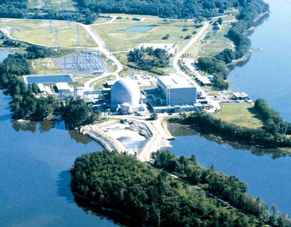
Photos
Photos of this facility from the NukeWorker photo gallery. Click the header or any photo to browse the full album.

3538 views")


3334 views")

Maine Yankee nuclear power plant, shown in Wisscasset Maine in this October 12, 1994 photo from files, will reportedly be prepared for possible reduced power output, according to Maine Yankee officials. The contingency plan is in the event technicians were wrong about the impact of a $40 million steam generator repair on the plant's efficiency.
Keywords: Maine Yankee Nuclear Power Plant (decommissioned)
3799 views")

3479 views")

13329 views")
Ownership & Construction
The utility or company that owns and operates the facility, the architect-engineer responsible for plant design, and the primary construction contractor. Click names to view all facilities by that entity on the map.
Technical Specs
Reactor design specifications including type (PWR/BWR), containment design, nuclear steam supply system manufacturer, thermal and electrical power ratings, and current operational status.
Reactor Type:
PWR
Containment:
PWR-DRYAMB
NSS Supplier:
COMB CE
Thermal Power:
2700 MWt
Net Capacity:
860 MWe
Status:
DECON
Licensing
NRC licensing history including docket number, license type and number, construction permit date, operating license issuance, commercial operation date, license renewal, and expiration date.
Docket #:
05000309
License #:
DPR-36
License Type:
OL-FP
Const. Permit:
1968-10-21
Operating Lic:
1973-06-29
Commercial Op:
1972-12-28
License Exp:
2008-10-21