

Hague
Facility Data
Fuel Cycle Facilities
Fuel cycle plants at this site, as listed in the IAEA Nuclear Fuel Cycle Facilities Database: what each plant does, its scale and design capacity, the years it operated, its current status and who operates it.
9 facilities: 6 in operation, 2 decommissioning, 1 decommissioned.
| Facility | Type | Scale | Design Capacity | Operated | Status | Operator |
|---|---|---|---|---|---|---|
| La Hague - NPH | AFR Wet Spent Fuel Storage (Pool) | Commercial | 2000 t HM | 1981– | In Operation | Orano |
| La Hague - C | AFR Wet Spent Fuel Storage (Pool) | Commercial | 4800 t HM | 1984– | In Operation | Orano |
| La Hague - D | AFR Wet Spent Fuel Storage (Pool) | Commercial | 4600 t HM | 1986– | In Operation | Orano |
| La Hague - E | AFR Wet Spent Fuel Storage (Pool) | Commercial | 6200 t HM | 1988– | In Operation | Orano |
| La Hague - UP3 | Spent Fuel Reprocessing - aqueous route | Commercial | 1000 t HM/year | 1990– | In Operation | Orano |
| La Hague - UP2-800 | Spent Fuel Reprocessing - aqueous route | Commercial | 1000 t HM/year | 1996– | In Operation | Orano |
| La Hague - UP2-400 | Spent Fuel Reprocessing - aqueous route | Commercial | 400 t HM/year | 1966–2004 | Decommissioning | Orano |
| La Hague - AT1 | Spent Fuel Reprocessing - aqueous route | Pilot plant | 0.365 t HM/year | 1969–1979 | Decommissioned | Orano |
| La Hague - HAO | AFR Wet Spent Fuel Storage (Pool) | Commercial | 400 t HM | 1976– | Decommissioning | Orano |
Source: IAEA Nuclear Fuel Cycle Facilities Database (NFCFDB), as of 2026-10-13.
Working Here
Per Diem Rates FY 2026
Per diem covers lodging and meals & incidental expenses (M&IE) for government and contractor travel near this facility. Rates are from the U.S. State Department foreign per diem tables for FY 2026.
$220
Lodging/Night
$132
M&IE/Day
$352
Total/Day
France: rate for locations the State Department does not list separately
U.S. Department of State foreign per diem, for U.S. government and contractor travel.
Photos
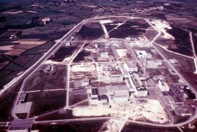
Photos of this facility from the NukeWorker photo gallery. Click the header or any photo to browse the full album.


Facility Map
Interactive satellite map showing the facility's geographic location. Marker color indicates current status: green for online, red for offline, orange for reduced power. Click the header to open in Google Maps satellite view.
49.6768, -1.8819
Location & Contact
Physical address, phone number, and website for this facility. Use the directions link to get driving directions via Google Maps.